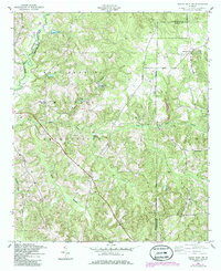
1955 Map of Buena Vista NW
USGS Topo · Published 1986About this map
The Fort Benning Military Reservation dominates this 1955 landscape, occupying a vast portion of the terrain where Muscogee, Chattahoochee, and Marion counties meet. The map documents a rural transition zone defined by numerous small water bodies and drainage systems, such as Averetts Pond and Upatoi Creek in the north, and the network of Pine Knot Creek and Little Pine Knot Creek to the south. Small family or community landmarks persist despite the military presence, including Gallups Millpond and the County Line Ch near the southern boundary.
Find a feature on this map
20 named features on this map. Tap any name to fly to it.
Don’t see what you’re looking for? This feature index may not catch every label — zoom into the map to look around manually.
Map Details
Editions of this 1955 Buena Vista NW Map
3 editions found
Other maps of this area

1907 · Talbotton
USGS Topo · 1:125,000

1908 · Columbus
USGS Topo · 1:62,500

1929 · Columbus
USGS Topo · 1:48,000

1947 · Columbus
USGS Topo · 1:62,500

1949 · Midland
USGS Topo · 1:24,000

1949 · Glen Alta
USGS Topo · 1:24,000

1949 · Upatoi
USGS Topo · 1:24,000

1949 · Ochillee
USGS Topo · 1:24,000

1949 · Buena Vista NW
USGS Topo · 1:24,000

1949 · Cusseta
USGS Topo · 1:24,000