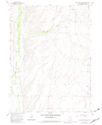
1967 Map of Buena Vista Ranch
USGS Topo · Published 1983About this map
Marys River flows through the heart of this Elko County landscape, defining the character of the river basin as it appeared in the late 1960s. The Buena Vista Ranch serves as the primary landmark in this ranching country, situated near a Gaging Sta along the river's path. The terrain is deeply inscribed by seasonal drainage patterns, notably Stormy Creek and Stormy Gulch, which feed into the main valley from the surrounding high ground.
Find a feature on this map
11 named features on this map. Tap any name to fly to it.
Don’t see what you’re looking for? This feature index may not catch every label — zoom into the map to look around manually.
Map Details
Editions of this 1967 Buena Vista Ranch Map
2 editions found
Other maps of this area

1955 · Wells
USGS Topo · 1:250,000

1958 · Wells
USGS Topo · 1:250,000

1961 · Wells
USGS Topo · 1:250,000

1967 · Black Butte SW
USGS Topo · 1:24,000

1967 · Black Butte
USGS Topo · 1:24,000

1967 · Hot Springs Creek
USGS Topo · 1:24,000

1967 · Buena Vista Ranch
USGS Topo · 1:24,000

1967 · Black Butte NE
USGS Topo · 1:24,000

1967 · Hanks Creek NE
USGS Topo · 1:24,000

1968 · Marys River Basin SE
USGS Topo · 1:24,000