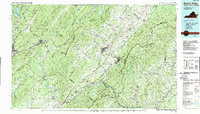
1986 Map of Buena Vista
USGS Topo · Published 1989About this map
The Alleghany Mountains and Blue Ridge Mountains converge here, framing a landscape defined by the drainage of the James River and Maury River. This mid-1980s data illustrates the region's concentration of academic and military institutions, including Washington and Lee University, the Virginia Military Institute, and Sweet Briar College. The industrial and transport corridors are clearly etched along the river valleys, where the Chesapeake & Ohio and Norfolk & Western RR lines follow the water gaps through the ridges.
Find a feature on this map
148 named features on this map. Tap any name to fly to it.
Don’t see what you’re looking for? This feature index may not catch every label — zoom into the map to look around manually.
Map Details
Editions of this 1986 Buena Vista Map
2 editions found
Other maps of this area

1887 · Lewisburg
USGS Topo · 1:125,000

1890 · Roanoke
USGS Topo · 1:125,000

1890 · Christiansburg
USGS Topo · 1:125,000

1891 · Roanoke
USGS Topo · 1:125,000

1891 · Lewisburg
USGS Topo · 1:125,000

1891 · Huntersville
USGS Topo · 1:125,000

1892 · Lynchburg
USGS Topo · 1:125,000

1892 · Buckingham
USGS Topo · 1:125,000

1892 · Appomattox
USGS Topo · 1:125,000

1892 · Harrisonburg
USGS Topo · 1:125,000