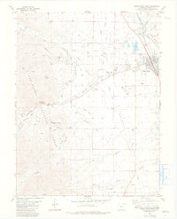
1982 Map of Buena Vista West
USGS Topo · Published 1983About this map
Buena Vista sits at the foot of the San Isabel range, serving as a hub for the rail and water networks of the Upper Arkansas Valley in the early 1980s. The Denver and Rio Grande Western Railroad follows the curve of the Arkansas River, while a complex system of irrigation infrastructure, including the Mc Kenna Ditch and Maxwell Ditch, reveals the intensive land management required in this high-altitude landscape.
Find a feature on this map
50 named features on this map. Tap any name to fly to it.
Don’t see what you’re looking for? This feature index may not catch every label — zoom into the map to look around manually.
Map Details
Editions of this 1982 Buena Vista West Map
4 editions found
Other maps of this area

1940 · Garfield
USGS Topo · 1:62,500

1945 · Garfield
USGS Topo · 1:62,500

1955 · Buena Vista
USGS Topo · 1:62,500

1955 · Mount Harvard
USGS Topo · 1:62,500

1956 · Poncha Springs
USGS Topo · 1:62,500

1956 · Montrose
USGS Topo · 1:250,000

1959 · Montrose
USGS Topo · 1:250,000

1960 · Montrose
USGS Topo · 1:250,000

1968 · Montrose
USGS Topo · 1:250,000

1982 · Buena Vista West
USGS Topo · 1:24,000