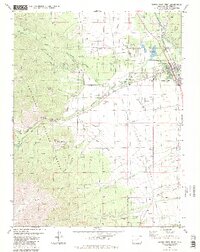
1982 Map of Buena Vista West
USGS Topo · Published 1987About this map
Buena Vista sits at the junction of mountain runoff and the Arkansas River, serving as a central hub for ranching and recreation in the early 1980s. The landscape is defined by an intricate network of irrigation channels like the Mary Bray Ditch and Mc Kenna Ditch, which divert water from Cottonwood Creek to the surrounding valley. To the west, the San Isabel National Forest rises toward Bald Mountain, where a legacy of extraction is visible through the Latchaw Mine and various Prospect points.
Find a feature on this map
52 named features on this map. Tap any name to fly to it.
Don’t see what you’re looking for? This feature index may not catch every label — zoom into the map to look around manually.
Map Details
Editions of this 1982 Buena Vista West Map
4 editions found
Other maps of this area

1940 · Garfield
USGS Topo · 1:62,500

1945 · Garfield
USGS Topo · 1:62,500

1955 · Buena Vista
USGS Topo · 1:62,500

1955 · Mount Harvard
USGS Topo · 1:62,500

1956 · Poncha Springs
USGS Topo · 1:62,500

1956 · Montrose
USGS Topo · 1:250,000

1959 · Montrose
USGS Topo · 1:250,000

1960 · Montrose
USGS Topo · 1:250,000

1968 · Montrose
USGS Topo · 1:250,000

1982 · Buena Vista West
USGS Topo · 1:24,000