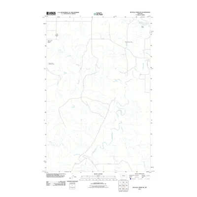
2011 Map of Buffalo Creek NE
USGS Topo · Published 2011About this map
The Redwater River meanders through this section of McCone County, creating a complex drainage network defined by its many tributaries. In this prairie landscape, water management is central to the land's utility, as seen in the series of small impoundments like Smile Number 1 Dam, Berrys Land Number 3 Dam, and Berrys Land Number 2 Dam. These features, along with the 2350 Redwater Dam, reflect the localized efforts to capture runoff in a region where creeks such as Hay Creek, Alkali Creek, and Sullivan Creek often run dry. The terrain is marked by distinct geographic features like Gold Gulch in the north and the winding paths of Cow Creek and Pasture Creek, while a sparse network of rural routes including Fas 254 and Road 617 provides the primary access across the wide drainage basins.
Find a feature on this map
14 named features on this map. Tap any name to fly to it.
Don’t see what you’re looking for? This feature index may not catch every label — zoom into the map to look around manually.
Map Details
Editions of this 2011 Buffalo Creek NE Map
This is the sole edition of this map. No revisions or reprints were ever made.
Other maps of this area

1954 · Glendive
USGS Topo · 1:250,000

1957 · Glendive
USGS Topo · 1:250,000

1958 · Glendive
USGS Topo · 1:250,000

1983 · Buffalo Creek NE
USGS Topo · 1:24,000
1983 · Kraut Coulee
USGS Topo · 1:24,000

1983 · Circle Reservoir
USGS Topo · 1:24,000

1983 · Buffalo Creek
USGS Topo · 1:24,000

1983 · Beery Reservoir
USGS Topo · 1:24,000

1983 · Richey NW
USGS Topo · 1:24,000
1983 · Lisk Creek
USGS Topo · 1:24,000