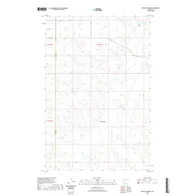
2020 Map of Buffalo Creek NE
USGS Topo · Published 2020About this map
The Redwater River and its network of tributaries define this reach of the eastern Montana plains along the boundary of McCone and Dawson counties. The landscape is marked by a complex system of drainage coulees and gulches, including Gold Gulch in the northeast and numerous seasonal streams such as Hay Cr, Alkali Cr, and Sullivan Cr. This 2020 survey illustrates the sparsely populated ranching territory characterized by long-established section lines and isolated rural routes. Local infrastructure is represented by roads like Beery Rd and E Hereford Rd, alongside state-designated secondary routes such as Fas 254. The map provides a clear record of the watershed patterns that have dictated land use and livestock movement in this portion of the Missouri River basin for generations.
Find a feature on this map
18 named features on this map. Tap any name to fly to it.
Don’t see what you’re looking for? This feature index may not catch every label — zoom into the map to look around manually.
Map Details
Editions of this 2020 Buffalo Creek NE Map
This is the sole edition of this map. No revisions or reprints were ever made.
Other maps of this area

1954 · Glendive
USGS Topo · 1:250,000

1957 · Glendive
USGS Topo · 1:250,000

1958 · Glendive
USGS Topo · 1:250,000

1983 · Buffalo Creek NE
USGS Topo · 1:24,000
1983 · Kraut Coulee
USGS Topo · 1:24,000

1983 · Circle Reservoir
USGS Topo · 1:24,000

1983 · Buffalo Creek
USGS Topo · 1:24,000

1983 · Beery Reservoir
USGS Topo · 1:24,000

1983 · Richey NW
USGS Topo · 1:24,000
1983 · Lisk Creek
USGS Topo · 1:24,000