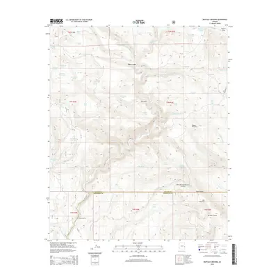
2014 Map of Buffalo Crossing
USGS Topo · Published 2014About this map
Buffalo Crossing and Three Forks serve as key landmarks in this high-altitude landscape within the Apache National Forest. This 2014 survey documents a terrain defined by complex water management and natural hydrology, featuring an extensive network of stock tanks such as Bear Stock Tank and West Side Tank alongside the winding N Fork E Fork Black River. The area is geographically notable for its position spanning the Apache and Greenlee County border, where the topography shifts from the peaks of Tenney Mountain and Mid Mountain into the depths of Bardman Canyon.
Find a feature on this map
60 named features on this map. Tap any name to fly to it.
Don’t see what you’re looking for? This feature index may not catch every label — zoom into the map to look around manually.
Map Details
Editions of this 2014 Buffalo Crossing Map
This is the sole edition of this map. No revisions or reprints were ever made.
Other maps of this area

1922 · Nutrioso
USGS Topo · 1:125,000

1954 · Clifton
USGS Topo · 1:250,000

1957 · Clifton
USGS Topo · 1:250,000

1958 · Clifton
USGS Topo · 1:250,000

1958 · Alpine
USGS Topo · 1:62,500

1958 · Hannagan Meadow
USGS Topo · 1:62,500

1958 · Big Lake
USGS Topo · 1:62,500

1961 · Blue
USGS Topo · 1:62,500

1962 · Clifton
USGS Topo · 1:250,000
1981 · Nutrioso
USGS Topo · 1:100,000