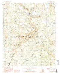
1991 Map of Buffalo Crossing
USGS Topo · Published 1991About this map
The Apache National Forest dominates this highland landscape, where the Black River system carves deep canyons through the timber. Compiled from mid-1980s data, the sheet documents a network of seasonal recreation sites and remote landmarks along the Apache and Greenlee county line. The confluence of the North Fork and East Fork Black River at Three Forks provides a focal point for the complex drainage system of Boneyard Creek and Coyote Creek.
Find a feature on this map
36 named features on this map. Tap any name to fly to it.
Don’t see what you’re looking for? This feature index may not catch every label — zoom into the map to look around manually.
Map Details
Editions of this 1991 Buffalo Crossing Map
This is the sole edition of this map. No revisions or reprints were ever made.
Other maps of this area

1922 · Nutrioso
USGS Topo · 1:125,000

1954 · Clifton
USGS Topo · 1:250,000

1957 · Clifton
USGS Topo · 1:250,000

1958 · Clifton
USGS Topo · 1:250,000

1958 · Alpine
USGS Topo · 1:62,500

1958 · Hannagan Meadow
USGS Topo · 1:62,500

1958 · Big Lake
USGS Topo · 1:62,500

1961 · Blue
USGS Topo · 1:62,500

1962 · Clifton
USGS Topo · 1:250,000
1981 · Nutrioso
USGS Topo · 1:100,000