
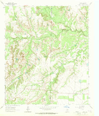
1963 Map of Buffalo Draw
USGS Topo · Published 1964About this map
Buffalo Draw carves through the high plains of West Texas in this early 1960s topographic record, where the landscape is defined by a dense network of intermittent drainage systems. Spanning the Mitchell Co Sterling Co boundary, the area shows a distinct transition from open rangeland to the dissected terrain surrounding Mustang Creek and Hackberry Creek. The mapping reveals the practical adaptations of cattle ranching and early industry in this arid environment, evidenced by labels like Hyman Tank and a small Quarry near the northern boundary. Genealogists and local historians will find the Knobhill Cem situated on the higher ground between Forest Creek and Dry Hollow Creek, serving as a permanent landmark in a region characterized by shifting seasonal waters and scattered ranch infrastructure.
Find a feature on this map
11 named features on this map. Tap any name to fly to it.
Don’t see what you’re looking for? This feature index may not catch every label — zoom into the map to look around manually.
Map Details
Editions of this 1963 Buffalo Draw Map
This is the sole edition of this map. No revisions or reprints were ever made.
Other maps of this area

1954 · Big Spring
USGS Topo · 1:250,000

1954 · San Angelo
USGS Topo · 1:250,000

1958 · San Angelo
USGS Topo · 1:250,000

1958 · Big Spring
USGS Topo · 1:250,000

1959 · Spade Ranch
USGS Topo · 1:24,000

1959 · McWhorter Mountain
USGS Topo · 1:24,000

1962 · Hyman NE
USGS Topo · 1:24,000

1963 · Cumbie Draw NE
USGS Topo · 1:24,000

1963 · Hayrick Mountain
USGS Topo · 1:24,000
1963 · Hyman
USGS Topo · 1:24,000