
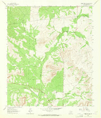
1963 Map of Cumbie Draw NE
USGS Topo · Published 1964About this map
The North Concho River winds through the southern portion of this landscape, carving a path through the limestone-cut terrain of Sterling County in the early 1960s. The region is characterized by seasonal watercourses like Hackberry Creek, Willow Creek, and Chalk Creek, which drain toward the river basin. Human activity is marked by the presence of Reed Ranch and several scattered Gravel Pits, alongside industrial corridors defined by multiple Pipelines. Surveyors also noted several Prospects throughout the hills, indicating an era of mineral exploration or site testing. The map reveals a transition in land use, where traditional ranching life exists alongside emerging utility infrastructure and small-scale resource extraction typical of the West Texas plateau during this period.
Find a feature on this map
10 named features on this map. Tap any name to fly to it.
Don’t see what you’re looking for? This feature index may not catch every label — zoom into the map to look around manually.
Map Details
Editions of this 1963 Cumbie Draw NE Map
2 editions found
Other maps of this area

1954 · Big Spring
USGS Topo · 1:250,000

1954 · San Angelo
USGS Topo · 1:250,000

1958 · San Angelo
USGS Topo · 1:250,000

1958 · Big Spring
USGS Topo · 1:250,000

1959 · McWhorter Mountain
USGS Topo · 1:24,000

1963 · Cumbie Draw
USGS Topo · 1:24,000

1963 · Glass Ranch
USGS Topo · 1:24,000

1963 · Buffalo Draw
USGS Topo · 1:24,000

1963 · Hayrick Mountain
USGS Topo · 1:24,000
1963 · Sand Bluff Draw
USGS Topo · 1:24,000