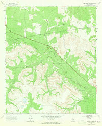
1963 Map of Sand Bluff Draw
USGS Topo · Published 1965About this map
The North Concho River winds through the heart of this West Texas landscape, cutting a path between the elevated plateaus and draws of Sterling County. In the early 1960s, the area's economy is clearly anchored by cattle ranching and modern energy infrastructure, as evidenced by large holdings like Cole Ranch, Reed Ranch, and McEntire Ranch interspersed with prominent pipelines. The terrain is defined by rugged limestone escarpments like Sand Bluff and a network of seasonal drainages including Sand Bluff Draw, Dobson Creek, and Gardener Draw. A small Quarry and a Roadside Park along Highway 87 provide evidence of local industry and the increasing accessibility of the region during the post-war era. The density of bench marks like BM 2465 and BM 2442 reflects the precise surveying required to manage these sprawling ranchlands and utility corridors.
Find a feature on this map
17 named features on this map. Tap any name to fly to it.
Don’t see what you’re looking for? This feature index may not catch every label — zoom into the map to look around manually.
Map Details
Editions of this 1963 Sand Bluff Draw Map
2 editions found
Other maps of this area

1941 · Big Spring South
USGS Topo · 1:62,500

1942 · Big Spring South
USGS Topo · 1:62,500

1954 · Big Spring
USGS Topo · 1:250,000

1954 · San Angelo
USGS Topo · 1:250,000

1958 · San Angelo
USGS Topo · 1:250,000

1958 · Big Spring
USGS Topo · 1:250,000

1963 · Cumbie Draw
USGS Topo · 1:24,000

1963 · Glass Ranch
USGS Topo · 1:24,000

1963 · Cumbie Draw NE
USGS Topo · 1:24,000

1963 · Buffalo Draw
USGS Topo · 1:24,000