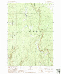
1986 Map of Buffalo Lake
USGS Topo · Published 1986About this map
Yellowstone National Park and Targhee National Forest converge on this 1980s topographic record, revealing a landscape defined by high-altitude drainages and protected wilderness. The state line between Idaho and Wyoming bisects the terrain, which is dominated by the intricate headwaters of the Fall River system. Water bodies like Buffalo Lake and the branching reaches of Cascade Creek and Robinson Creek illustrate the complex hydrology of the Bechler region. The map provides a look at the transition between the managed timberlands of the Targhee and the preservation of the park. Notable landmarks such as Snow Creek Butte stand out against a network of small creeks including Partridge Creek, Pack Creek, and Split Creek, providing a detailed view of this remote corner where Fremont and Teton counties meet.
Find a feature on this map
15 named features on this map. Tap any name to fly to it.
Don’t see what you’re looking for? This feature index may not catch every label — zoom into the map to look around manually.
Map Details
Editions of this 1986 Buffalo Lake Map
This is the sole edition of this map. No revisions or reprints were ever made.
Other maps of this area

1886 · Shoshone
USGS Topo · 1:125,000

1888 · Shoshone
USGS Topo · 1:125,000

1895 · Shoshone
USGS Topo · 1:125,000

1901 · Shoshone
USGS Topo · 1:125,000

1908 · Shoshone
USGS Topo · 1:125,000

1911 · Shoshone
USGS Topo · 1:125,000

1955 · Ashton
USGS Topo · 1:250,000

1956 · Old Faithful
USGS Topo · 1:62,500

1956 · Grassy Lake Reservoir
USGS Topo · 1:62,500

1957 · Warm River Butte
USGS Topo · 1:62,500