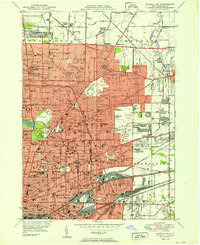
1950 Map of Buffalo NE
USGS Topo · Published 1950About this map
Buffalo and its expanding northern suburbs appear at a moment of significant mid-century density, dominated by an intricate network of transit and community institutions. The urban landscape is anchored by massive parklands and cultural landmarks like Delaware Park, the Buffalo Zoological Garden, and the Museum of Science in Humboldt Park. A sprawling complex of major medical facilities including Sisters Hospital and Millard Fillmore Hospital serves the growing population, while the presence of both Civic Stadium and Offerman Stadium highlights the city's active social and athletic life. On the northern edge, the University of Buffalo campus stands near established neighborhoods like Kenilworth and Eggertsville. The region's history is further reflected in its extensive burial grounds, from the landscaped Forest Lawn Cemetery to the vast United Catholic Cemetery and St Stanislaus Cemetery, which together occupy significant portions of the eastern terrain alongside the tracks of the NYC RR and Erie RR.
Find a feature on this map
133 named features on this map. Tap any name to fly to it.
Don’t see what you’re looking for? This feature index may not catch every label — zoom into the map to look around manually.
Map Details
Editions of this 1950 Buffalo NE Map
This is the sole edition of this map. No revisions or reprints were ever made.
Other maps of this area

1894 · Buffalo
USGS Topo · 1:62,500

1897 · Tonawanda
USGS Topo · 1:62,500

1897 · Lockport
USGS Topo · 1:62,500

1899 · Niagara
USGS Topo · 1:125,000

1900 · Tonawanda
USGS Topo · 1:62,500

1901 · Buffalo
USGS Topo · 1:62,500

1901 · Tonawanda
USGS Topo · 1:62,500

1902 · Lockport
USGS Topo · 1:62,500

1905 · Depew
USGS Topo · 1:62,500

1905 · Lockport
USGS Topo · 1:62,500