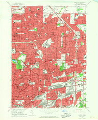
1965 Map of Buffalo NE
USGS Topo · Published 1967About this map
Buffalo and its northern suburbs are shown at a peak of post-war expansion, characterized by a dense grid of residential neighborhoods, parish schools, and a maturing expressway network. The landscape is defined by massive public and institutional spaces, from the sprawling State University at Buffalo and Veterans Hospital to the cultural anchor of the Buffalo Zoo. Significant genealogical resources are evident in the numerous cemeteries that ring the city center, including Forest Lawn Cemetery, Mt Calvary Cemetery, and the United Catholic Cemetery.
Find a feature on this map
181 named features on this map. Tap any name to fly to it.
Don’t see what you’re looking for? This feature index may not catch every label — zoom into the map to look around manually.
Map Details
Editions of this 1965 Buffalo NE Map
This is the sole edition of this map. No revisions or reprints were ever made.
Other maps of this area

1894 · Buffalo
USGS Topo · 1:62,500

1897 · Tonawanda
USGS Topo · 1:62,500

1897 · Lockport
USGS Topo · 1:62,500

1899 · Niagara
USGS Topo · 1:125,000

1900 · Tonawanda
USGS Topo · 1:62,500

1901 · Buffalo
USGS Topo · 1:62,500

1901 · Tonawanda
USGS Topo · 1:62,500

1902 · Lockport
USGS Topo · 1:62,500

1905 · Depew
USGS Topo · 1:62,500

1905 · Lockport
USGS Topo · 1:62,500