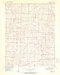
1951 Map of Buffalo NW
USGS Topo · Published 1951About this map
Lindley Creek and its many tributaries, including Jordan Creek and Brush Creek, carve through the rural landscape of the Missouri River Basin at the border of Polk and Dallas counties. This 1951 survey reveals a dense network of local civic life, with one-room schoolhouses and country churches serving as the primary anchors for the surrounding farmsteads. Scattered throughout the townships of North Benton, Benton, and Greene, landmarks like Concord Sch and Reynolds Chapel speak to the area's mid-century community structure. Family history is well-preserved through several small burial grounds, such as Breshears Cem and Ragsdale Cem, providing essential points of reference for genealogists tracking local settlers. The map illustrates a period when rural school districts like Brush Creek Sch and Crescent Sch were still the focal points of Missouri's countryside.
Find a feature on this map
20 named features on this map. Tap any name to fly to it.
Don’t see what you’re looking for? This feature index may not catch every label — zoom into the map to look around manually.
Map Details
Editions of this 1951 Buffalo NW Map
2 editions found
Other maps of this area

1884 · Bolivar
USGS Topo · 1:125,000

1892 · Bolivar
USGS Topo · 1:125,000

1949 · Sentinel
USGS Topo · 1:24,000

1950 · Sentinel
USGS Topo · 1:24,000

1950 · Buffalo NW
USGS Topo · 1:24,000

1950 · Polk
USGS Topo · 1:24,000

1950 · Urbana
USGS Topo · 1:24,000

1951 · Buffalo NW
USGS Topo · 1:24,000

1951 · Urbana
USGS Topo · 1:24,000

1951 · Polk
USGS Topo · 1:24,000