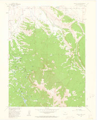
1956 Map of Buffalo Peak
USGS Topo · Published 1963About this map
Buffalo Ranch and nearby outfits like Wade Ranch and Shamrock Ranch anchor the high country of Jackson County in the mid-1950s. This survey illustrates the complex irrigation system required for ranching in the Colorado Rockies, featuring the Slack Ditch, Allard DITCH, and Cochrane Ditch winding through the drainage of Coyote Creek. To the south, the landscape shifts into the protected timberlands of Routt National Forest and Arapaho National Forest. High-altitude water sources are plentiful, from the Arapaho Lakes cluster to the Two Ledge Reservoir. The map documents a rugged working landscape where cattle operations met the federal forest boundary, connected by the Buffalo Pass Trail and overseen by the towering Buffalo Peak. Notable landmarks such as the Aspen Knoll Cabin and a lone Oil Well near Buffalo Creek reflect the era's diverse land use.
Find a feature on this map
54 named features on this map. Tap any name to fly to it.
Don’t see what you’re looking for? This feature index may not catch every label — zoom into the map to look around manually.
Map Details
Editions of this 1956 Buffalo Peak Map
5 editions found
Other maps of this area

1954 · Craig
USGS Topo · 1:250,000

1955 · Coalmont
USGS Topo · 1:24,000

1955 · Owl Ridge
USGS Topo · 1:24,000

1955 · Mac Farlane Reservoir
USGS Topo · 1:24,000

1955 · Walden
USGS Topo · 1:62,500

1956 · Spicer Peak
USGS Topo · 1:24,000

1956 · Parkview Mountain
USGS Topo · 1:24,000

1956 · Buffalo Peak
USGS Topo · 1:24,000

1956 · Whiteley Peak
USGS Topo · 1:24,000

1956 · Hyannis Peak
USGS Topo · 1:24,000