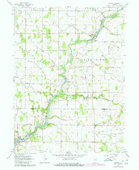
1962 Map of Buffalo
USGS Topo · Published 1980About this map
The Tippecanoe River meanders through this portion of north-central Indiana, defining the physical and social landscape of Pulaski and White Counties. The river serves as the primary corridor for small riverbank communities like Pulaski and Buffalo, while the surrounding flatlands are dominated by a systematic network of drainage ditches and family-named farm roads such as Swingle and Harpster. This agricultural interior is dotted with several houses of worship and burial grounds, including St Josephs Ch and White Oak Ch, which provided essential focal points for rural life. Along the river, Camp Buffalo appears as a notable landmark near the southern edge. The map reflects a mid-century rural economy where small crossroads like Headlee and Lakeside anchored the scattered farmsteads, connected by a grid of improved and unimproved roads that persist in the landscape today.
Find a feature on this map
35 named features on this map. Tap any name to fly to it.
Don’t see what you’re looking for? This feature index may not catch every label — zoom into the map to look around manually.
Map Details
Editions of this 1962 Buffalo Map
2 editions found
Other maps of this area

1953 · Chicago
USGS Topo · 1:250,000

1953 · Danville
USGS Topo · 1:250,000

1955 · Danville
USGS Topo · 1:250,000

1956 · Danville
USGS Topo · 1:250,000

1957 · Chicago
USGS Topo · 1:250,000

1962 · Buffalo
USGS Topo · 1:24,000

1962 · Monon NE
USGS Topo · 1:24,000

1962 · Winamac
USGS Topo · 1:24,000

1962 · Star City
USGS Topo · 1:24,000

1962 · Burnettsville
USGS Topo · 1:24,000