
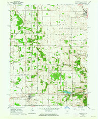
1962 Map of Burnettsville
USGS Topo · Published 1964About this map
Burnettsville and Royal Center anchor this mid-century survey of the Indiana landscape along the border of White and Cass counties. The area is defined by a dense network of water management features, including the Kennel Ditch, Burgett Ditch, and Berkshire Ditch, which redirect flow across the agricultural plains toward Pike Creek and Crooked Creek. In the southern portion of the map, the Pennsylvania railroad line runs parallel to the shore of Lake Cicott, passing through the eponymous settlement where a Township Sch and a specialized Micro-Midget Racetrack reflect the local community life of the early 1960s.
Find a feature on this map
41 named features on this map. Tap any name to fly to it.
Don’t see what you’re looking for? This feature index may not catch every label — zoom into the map to look around manually.
Map Details
Editions of this 1962 Burnettsville Map
2 editions found
Other maps of this area

1953 · Danville
USGS Topo · 1:250,000

1955 · Danville
USGS Topo · 1:250,000

1956 · Danville
USGS Topo · 1:250,000

1960 · Lucerne
USGS Topo · 1:24,000

1960 · Grass Creek
USGS Topo · 1:24,000

1962 · Buffalo
USGS Topo · 1:24,000

1962 · Burrows
USGS Topo · 1:24,000

1962 · Star City
USGS Topo · 1:24,000
1962 · Clymers
USGS Topo · 1:24,000
1962 · Yeoman
USGS Topo · 1:24,000