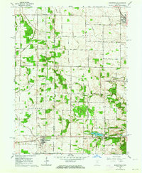
1962 Map of Burnettsville
USGS Topo · Published 1976About this map
Burnettsville anchors the southwestern corner of this survey, straddling the line between White and Cass Counties during the early 1960s. The landscape is defined by an extensive network of managed waterways, including Timmons Ditch, Burgett Ditch, and Kennel Ditch, which drain the agricultural plains of Boone, Jefferson, and Jackson townships. This engineering is essential to the region's productivity, supporting the rural homesteads connected by a rigid grid of gravel and paved roads.
Find a feature on this map
36 named features on this map. Tap any name to fly to it.
Don’t see what you’re looking for? This feature index may not catch every label — zoom into the map to look around manually.
Map Details
Editions of this 1962 Burnettsville Map
2 editions found
Other maps of this area

1953 · Danville
USGS Topo · 1:250,000

1955 · Danville
USGS Topo · 1:250,000

1956 · Danville
USGS Topo · 1:250,000

1960 · Lucerne
USGS Topo · 1:24,000

1960 · Grass Creek
USGS Topo · 1:24,000

1962 · Buffalo
USGS Topo · 1:24,000

1962 · Burrows
USGS Topo · 1:24,000

1962 · Star City
USGS Topo · 1:24,000

1962 · Burnettsville
USGS Topo · 1:24,000
1962 · Clymers
USGS Topo · 1:24,000