
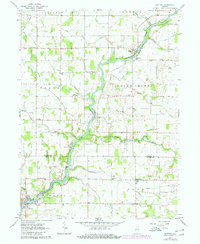
1962 Map of Buffalo
USGS Topo · Published 1963About this map
The Tippecanoe River meanders through the heart of this Indiana landscape, defining the character of the borderlands between Pulaski and White Counties. In the early 1960s, the area was a patchwork of agricultural townships including Jefferson, Monroe, Beaver, and Liberty. Small rural hubs like Buffalo, Pulaski, and Headlee served as local centers of gravity, connected by a network of drainage infrastructure like the Wallace Stout Ditch and Ackerman Ditch, which converted the natural marshlands into productive farmland.
Find a feature on this map
32 named features on this map. Tap any name to fly to it.
Don’t see what you’re looking for? This feature index may not catch every label — zoom into the map to look around manually.
Map Details
Editions of this 1962 Buffalo Map
2 editions found
Other maps of this area

1953 · Chicago
USGS Topo · 1:250,000

1953 · Danville
USGS Topo · 1:250,000

1955 · Danville
USGS Topo · 1:250,000

1956 · Danville
USGS Topo · 1:250,000

1957 · Chicago
USGS Topo · 1:250,000

1962 · Monon NE
USGS Topo · 1:24,000

1962 · Winamac
USGS Topo · 1:24,000

1962 · Star City
USGS Topo · 1:24,000

1962 · Burnettsville
USGS Topo · 1:24,000

1962 · Monticello North
USGS Topo · 1:24,000