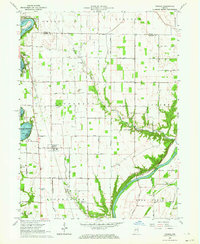
1962 Map of Yeoman
USGS Topo · Published 1964About this map
The Tippecanoe River and Wabash River dominate this early 1960s landscape, with the impounded waters of Lake Freeman shaping the development of leisure areas like Terrace Bay, Patton, and Roth Park. In the central agricultural plains, the town of Yeoman serves as a local hub along the Monon Railroad, which cuts north-south through the terrain. Evidence of early settlement patterns persists in the numerous family and community landmarks, such as Schock Cem and the Hickory Grove Ch. The map captures a transition where traditional river-bottom farming meets mid-century lakeside recreation. Significant hydrological features including Rattlesnake Creek and Deer Creek provide a look at the natural drainage of Carroll and White counties before modern development altered these rural corridors. The alignment of Towpath Road along the Wabash hints at the region's earlier transportation history.
Find a feature on this map
51 named features on this map. Tap any name to fly to it.
Don’t see what you’re looking for? This feature index may not catch every label — zoom into the map to look around manually.
Map Details
Editions of this 1962 Yeoman Map
This is the sole edition of this map. No revisions or reprints were ever made.
Other maps of this area

1953 · Danville
USGS Topo · 1:250,000

1955 · Danville
USGS Topo · 1:250,000

1956 · Danville
USGS Topo · 1:250,000

1962 · Flora
USGS Topo · 1:24,000

1962 · Burrows
USGS Topo · 1:24,000

1962 · Monticello South
USGS Topo · 1:24,000

1962 · Delphi
USGS Topo · 1:24,000

1962 · Burnettsville
USGS Topo · 1:24,000

1962 · Monticello North
USGS Topo · 1:24,000
1962 · Idaville
USGS Topo · 1:24,000