
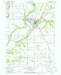
1962 Map of Delphi
USGS Topo · Published 1964About this map
Delphi serves as the central hub of this early 1960s survey, situated where Deer Creek meets the Wabash River. The landscape is defined by its deep historical layers, most notably the visible path of the Wabash and Erie Canal and segments of the Erie Canal (Abandoned) tracing the riverbanks. These 19th-century waterways are overlaid by the mid-century infrastructure of the Monon RR, which connects the town to outlying points like Harley Siding.
Find a feature on this map
53 named features on this map. Tap any name to fly to it.
Don’t see what you’re looking for? This feature index may not catch every label — zoom into the map to look around manually.
Map Details
Editions of this 1962 Delphi Map
2 editions found
Other maps of this area

1953 · Danville
USGS Topo · 1:250,000

1955 · Danville
USGS Topo · 1:250,000

1956 · Danville
USGS Topo · 1:250,000

1961 · Pyrmont
USGS Topo · 1:24,000

1961 · Lafayette East
USGS Topo · 1:24,000

1961 · Rossville
USGS Topo · 1:24,000

1962 · Flora
USGS Topo · 1:24,000

1962 · Burrows
USGS Topo · 1:24,000

1962 · Monticello South
USGS Topo · 1:24,000
1962 · Yeoman
USGS Topo · 1:24,000