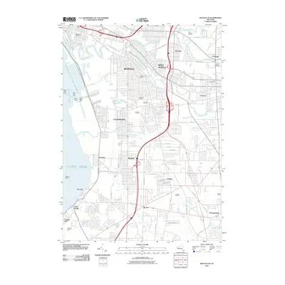
2010 Map of Buffalo SE
USGS Topo · Published 2010About this map
Lake Erie and the Buffalo Outer Harbor dominate the western edge of this suburban landscape, where the heavy industrial legacy of Lackawanna meets the expanding residential reaches of West Seneca and Orchard Park. The map documents a complex network of waterways, including Cazenovia Creek, Smoke Creek, and Buffalo Creek, which carve through the established neighborhoods of Winchester, Ebenezer, and Blasdell. Notable civic planning is evident in the circular junctions of McClellan Circle and McKinley Circle, while the region's history is preserved in numerous large memorial grounds like Holy Cross Cemetery and Saint Matthews Cemetery. The transition from the dense urban grid of south Buffalo to the more open developments of Windom and Big Tree illustrates the late twentieth-century growth patterns of the Southtowns. Shoreline features such as Stony Point and Seneca Shoal provide critical navigation context for the waterfront area near Athol Springs.
Find a feature on this map
75 named features on this map. Tap any name to fly to it.
Don’t see what you’re looking for? This feature index may not catch every label — zoom into the map to look around manually.
Map Details
Editions of this 2010 Buffalo SE Map
This is the sole edition of this map. No revisions or reprints were ever made.
Other maps of this area

1894 · Buffalo
USGS Topo · 1:62,500

1901 · Buffalo
USGS Topo · 1:62,500

1905 · Depew
USGS Topo · 1:62,500

1905 · Eden
USGS Topo · 1:62,500

1907 · Eden
USGS Topo · 1:62,500

1925 · Springville
USGS Topo · 1:62,500

1944 · Eden
USGS Topo · 1:62,500

1944 · Hamburg
USGS Topo · 1:31,680

1948 · Hamburg
USGS Topo · 1:24,000

1948 · Depew
USGS Topo · 1:62,500