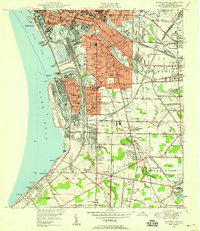
1948 Map of Buffalo SE
USGS Topo · Published 1959About this map
Industrial and residential development along the shores of Lake Erie defines this landscape south of Buffalo in the years following World War II. The map highlights the complex rail network serving the lakefront, including the South Buffalo Railway and Nickel Plate Road, which threaded through massive steel and shipping hubs at Stony Point and Lackawanna. Inland, the survey captures the transition from dense urban grids to the burgeoning suburban patterns of West Seneca and Orchard Park.
Find a feature on this map
75 named features on this map. Tap any name to fly to it.
Don’t see what you’re looking for? This feature index may not catch every label — zoom into the map to look around manually.
Map Details
Editions of this 1948 Buffalo SE Map
This is the sole edition of this map. No revisions or reprints were ever made.
Other maps of this area

1894 · Buffalo
USGS Topo · 1:62,500

1901 · Buffalo
USGS Topo · 1:62,500

1905 · Depew
USGS Topo · 1:62,500

1905 · Eden
USGS Topo · 1:62,500

1907 · Eden
USGS Topo · 1:62,500

1925 · Springville
USGS Topo · 1:62,500

1944 · Eden
USGS Topo · 1:62,500

1944 · Hamburg
USGS Topo · 1:31,680

1948 · Hamburg
USGS Topo · 1:24,000

1948 · Depew
USGS Topo · 1:62,500