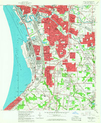
1965 Map of Buffalo SE
USGS Topo · Published 1967About this map
The industrial and residential expansion of Buffalo and its southern suburbs is frozen in time during the mid-1960s, showing a landscape defined by heavy rail infrastructure and lakefront development. The Buffalo Outer Harbor and Lake Erie shoreline dominate the west, where Stony Pt and the industrial works of Lackawanna meet the water. A dense network of transit, including the New York State Thruway and the Pennsylvania Railroad, carves through established neighborhoods like Woodlawn, Blasdell, and Ebenezer. The map reveals a community deeply rooted in its institutions, featuring numerous parochial schools and churches such as St Stephens Sch and St Michaels Ch, alongside significant medical facilities like Mercy Hospital. To the southeast, the terrain softens into the more suburban and rural fringes of Orchard Park and Hamburg, where features like Green Lake and the Sheldon Cem reflect a different pace of life away from the city core.
Find a feature on this map
79 named features on this map. Tap any name to fly to it.
Don’t see what you’re looking for? This feature index may not catch every label — zoom into the map to look around manually.
Map Details
Editions of this 1965 Buffalo SE Map
This is the sole edition of this map. No revisions or reprints were ever made.
Other maps of this area

1894 · Buffalo
USGS Topo · 1:62,500

1901 · Buffalo
USGS Topo · 1:62,500

1905 · Depew
USGS Topo · 1:62,500

1905 · Eden
USGS Topo · 1:62,500

1907 · Eden
USGS Topo · 1:62,500

1925 · Springville
USGS Topo · 1:62,500

1944 · Eden
USGS Topo · 1:62,500

1944 · Hamburg
USGS Topo · 1:31,680

1948 · Hamburg
USGS Topo · 1:24,000

1948 · Depew
USGS Topo · 1:62,500