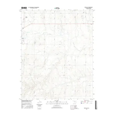
2016 Map of Buffalo SE
USGS Topo · Published 2016About this map
Buffalo sits at the western edge of this High Plains landscape, where the town’s street grid meets the expansive terrain of Harper County. The area is defined by the winding course of Buffalo Cr, which cuts eastward through the center of the sheet, and the presence of Glen Lake to the northeast. This 2016 survey highlights a pastoral region anchored by aviation and local heritage, with the Buffalo Municipal Airport serving as a prominent landmark just north of the community. Genealogists will find significant value in the distribution of local burial sites, including Hopewell Cem, Goldenrod Cem, and High Point Cem, each situated at different points in the rural sections. The map's grid of section roads, such as e0130 RD and n1940 RD, provides a clear framework for tracing land ownership and the rural homestead patterns of Northwest Oklahoma.
Find a feature on this map
29 named features on this map. Tap any name to fly to it.
Don’t see what you’re looking for? This feature index may not catch every label — zoom into the map to look around manually.
Map Details
Editions of this 2016 Buffalo SE Map
This is the sole edition of this map. No revisions or reprints were ever made.
Other maps of this area

1955 · Woodward
USGS Topo · 1:250,000

1958 · Woodward
USGS Topo · 1:250,000

1970 · Buffalo SE
USGS Topo · 1:24,000

1970 · Selman NW
USGS Topo · 1:24,000

1970 · Buffalo NW
USGS Topo · 1:24,000

1970 · Buffalo NE
USGS Topo · 1:24,000

1970 · Sleeping Bear Creek NW
USGS Topo · 1:24,000

1970 · Buffalo
USGS Topo · 1:24,000

1971 · Fort Supply NW
USGS Topo · 1:24,000

1971 · Selman
USGS Topo · 1:24,000