
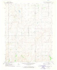
1970 Map of Sleeping Bear Creek NW
USGS Topo · Published 1973About this map
Fern Cem lies on the eastern edge of this western Oklahoma landscape, a quiet marker of early settlement in Harper County during the 1970s. The terrain is defined by its industrial and agricultural boundaries, divided into the Good, Saline, and Center townships. Natural drainage is primarily defined by Creek, Sand, and Gilbert, which carve through the topographical contours. The map reflects a period of active energy development, as evidenced by the distribution of numerous Gas Wells throughout the northern half of the quadrangle and a prominent Pipeline crossing the southwestern corner. These features, along with the detailed grid of section lines and fence lines, offer a window into the land management and resource extraction patterns that characterized this part of the state in the late twentieth century.
Find a feature on this map
9 named features on this map. Tap any name to fly to it.
Don’t see what you’re looking for? This feature index may not catch every label — zoom into the map to look around manually.
Map Details
Editions of this 1970 Sleeping Bear Creek NW Map
This is the sole edition of this map. No revisions or reprints were ever made.
Other maps of this area

1955 · Woodward
USGS Topo · 1:250,000

1958 · Woodward
USGS Topo · 1:250,000

1970 · Buffalo SE
USGS Topo · 1:24,000

1970 · Sleeping Bear Creek SW
USGS Topo · 1:24,000

1970 · Sleeping Bear Creek SE
USGS Topo · 1:24,000

1971 · Selman SE
USGS Topo · 1:24,000

1971 · Fort Supply
USGS Topo · 1:24,000

1971 · Selman
USGS Topo · 1:24,000

1971 · Fort Supply NE
USGS Topo · 1:24,000
1971 · Sleeping Bear Creek
USGS Topo · 1:24,000