
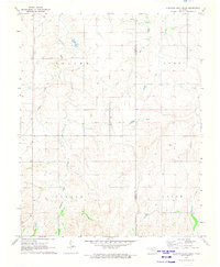
1971 Map of Selman
USGS Topo · Published 1973About this map
Selman serves as the central hub of this Harper County landscape, situated along the tracks of the Atchison Topeka and Santa Fe railroad. The terrain is defined by the winding course of Buffalo Creek, which carves a path through the prairie between the broad regions of Little, Good, and Saline. This survey, field checked in 1971, captures a period when the local economy was driven by natural resource extraction, evident in the numerous Gas Wells and Oil Wells scattered across the township lines. The infrastructure of the era is further highlighted by an extensive network of pipelines crossing the drainage of Sand Creek, reflecting the intensity of energy development in northwest Oklahoma during the early 1970s.
Find a feature on this map
12 named features on this map. Tap any name to fly to it.
Don’t see what you’re looking for? This feature index may not catch every label — zoom into the map to look around manually.
Map Details
Editions of this 1971 Selman Map
This is the sole edition of this map. No revisions or reprints were ever made.
Other maps of this area

1955 · Woodward
USGS Topo · 1:250,000

1958 · Woodward
USGS Topo · 1:250,000

1970 · Lookout
USGS Topo · 1:24,000

1970 · Buffalo SE
USGS Topo · 1:24,000

1970 · Selman NW
USGS Topo · 1:24,000

1970 · Buffalo NE
USGS Topo · 1:24,000

1970 · Sleeping Bear Creek NW
USGS Topo · 1:24,000

1971 · Selman SE
USGS Topo · 1:24,000

1971 · Fort Supply NE
USGS Topo · 1:24,000
1971 · Sleeping Bear Creek
USGS Topo · 1:24,000