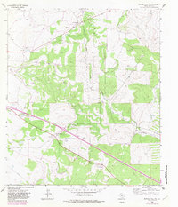
1963 Map of Buffalo Well SW
USGS Topo · Published 1983About this map
The North Llano River carves a winding path through this portion of Sutton County, defining a landscape of deep draws and high plateaus in the Edwards Plateau region. The map reveals a mid-century ranching economy organized around family-named holdings such as Halbert Ranch, Schwiening Ranch, and Stites Ranch. These large properties are crisscrossed by a network of ranch roads and a prominent pipeline corridor that cuts diagonally across the terrain.
Find a feature on this map
17 named features on this map. Tap any name to fly to it.
Don’t see what you’re looking for? This feature index may not catch every label — zoom into the map to look around manually.
Map Details
Editions of this 1963 Buffalo Well SW Map
2 editions found
Other maps of this area

1893 · Rock Springs
USGS Topo · 1:125,000

1893 · Fort McKavett
USGS Topo · 1:125,000

1954 · Sonora
USGS Topo · 1:250,000

1958 · Sonora
USGS Topo · 1:250,000

1963 · Steen Lake
USGS Topo · 1:24,000

1963 · Buffalo Well
USGS Topo · 1:24,000

1963 · Live Oak Draw
USGS Topo · 1:24,000

1963 · Buffalo Well NW
USGS Topo · 1:24,000

1963 · Buffalo Well SE
USGS Topo · 1:24,000

1963 · Buffalo Well SW
USGS Topo · 1:24,000