
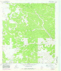
1963 Map of Steen Lake
USGS Topo · Published 1965About this map
The Miers Wilson Gas Field defines the industrial footprint of this Sutton County landscape in the early 1960s. Family-held ranching operations, including the Gene Wallace Ranch, Libb Wallace Ranch, and Robert Pfluger Ranch, are distributed across the terrain, indicating a legacy of private land use and rural settlement patterns. The natural geography is characterized by seasonal water features like Steen Lake and Lost Lake, alongside the prominent winding path of Eightmile Draw. Mapping of infrastructure such as the Radio Tower, numerous Gas Well sites, and an extensive network of pipelines reveals the intersection of traditional cattle ranching with the expanding energy sector. Local transport relies on routes like Bond Road, while the topography is punctuated by many Gravel Pit operations and deep-cut features like Bull Hollow.
Find a feature on this map
20 named features on this map. Tap any name to fly to it.
Don’t see what you’re looking for? This feature index may not catch every label — zoom into the map to look around manually.
Map Details
Editions of this 1963 Steen Lake Map
2 editions found
Other maps of this area

1893 · Rock Springs
USGS Topo · 1:125,000

1893 · Fort McKavett
USGS Topo · 1:125,000

1954 · Sonora
USGS Topo · 1:250,000

1958 · Sonora
USGS Topo · 1:250,000

1962 · Stewart Ranch
USGS Topo · 1:24,000

1963 · Harrison Ranch
USGS Topo · 1:24,000

1963 · Live Oak Draw
USGS Topo · 1:24,000

1963 · Buffalo Well SE
USGS Topo · 1:24,000

1963 · Buffalo Well SW
USGS Topo · 1:24,000

1964 · Sonora SE
USGS Topo · 1:24,000