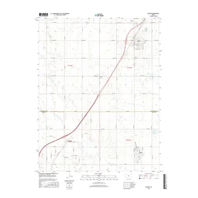
2015 Map of Buhler
USGS Topo · Published 2015About this map
The Little Arkansas River meanders across this landscape of the central Kansas plains, defining the boundary between MCPHERSON CO and RENO CO. This 2015 edition captures the established agricultural and transportation networks of the region, anchored by the settlements of Inman, Buhler, and Medora. The grid of section lines is notably preserved through named thoroughfares such as Cheyenne Rd and Apache Rd, reflecting the enduring impact of the Public Land Survey System on local geography. For family historians, the map is a detailed resource, plotting several burial sites including Evergreen Cem, North Inman Cem, and Buhler Thiessen Cem. Notable hydrologic features like Wolf Cr, Little Sinkhole, and Dirks Lake punctuate the prairie, providing a clear view of the natural drainage patterns surrounding the developed town centers.
Find a feature on this map
34 named features on this map. Tap any name to fly to it.
Don’t see what you’re looking for? This feature index may not catch every label — zoom into the map to look around manually.
Map Details
Editions of this 2015 Buhler Map
This is the sole edition of this map. No revisions or reprints were ever made.
Other maps of this area

1891 · Hutchinson
USGS Topo · 1:125,000

1893 · Hutchinson
USGS Topo · 1:125,000

1955 · Hutchinson
USGS Topo · 1:250,000

1959 · Hutchinson
USGS Topo · 1:250,000
1959 · Burrton
USGS Topo · 1:24,000
1960 · Hutchinson
USGS Topo · 1:24,000
1961 · Hutchinson SE
USGS Topo · 1:24,000

1964 · Windom SW
USGS Topo · 1:24,000

1964 · Conway
USGS Topo · 1:24,000

1965 · Mc Pherson South
USGS Topo · 1:24,000