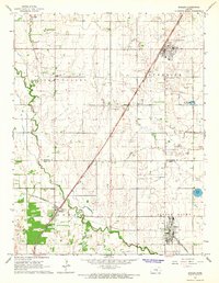
1965 Map of Buhler
USGS Topo · Published 1966About this map
The Little Arkansas River winds through the central Kansas prairie in this mid-1960s study, defining a landscape shaped by agricultural commerce and early transportation lines. The map captures the intersection of the Chicago Rock Island And Pacific and the ST Louis - San Francisco railroads, which facilitated the growth of rural hubs like Buhler and Inman. These small communities serve as the focal points for the surrounding township of Superior, where the grid of sections is punctuated by local landmarks such as Bethel Ch, Countryside Sch, and Hillcrest Sch. Beyond the towns, the topography reveals unique local features like the Little Sinkhole and Dirks Lake, while numerous burial sites including Inman North Cem and Evergreen Cem provide valuable touchstones for genealogists tracing family histories across the McPherson and Reno County line.
Find a feature on this map
22 named features on this map. Tap any name to fly to it.
Don’t see what you’re looking for? This feature index may not catch every label — zoom into the map to look around manually.
Map Details
Editions of this 1965 Buhler Map
This is the sole edition of this map. No revisions or reprints were ever made.
Other maps of this area

1891 · Hutchinson
USGS Topo · 1:125,000

1893 · Hutchinson
USGS Topo · 1:125,000

1955 · Hutchinson
USGS Topo · 1:250,000

1959 · Hutchinson
USGS Topo · 1:250,000
1959 · Burrton
USGS Topo · 1:24,000
1960 · Hutchinson
USGS Topo · 1:24,000
1961 · Hutchinson SE
USGS Topo · 1:24,000

1964 · Windom SW
USGS Topo · 1:24,000

1964 · Conway
USGS Topo · 1:24,000

1965 · Mc Pherson South
USGS Topo · 1:24,000