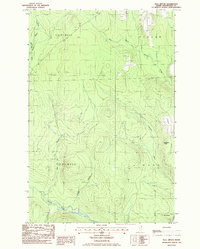
1986 Map of Bull Brook
USGS Topo · Published 1986About this map
The headwaters of the Salmon and Beaver Brooks define this northern Maine landscape, where logging and forest management shaped the local geography in the mid-1980s. The map illustrates a transitional period for the timberlands of Perham, Wade, and the surrounding townships. Isolated outposts such as Thompson Camp and Drost Camp are positioned near the network of streams, while a Lookout Tower atop Story Hill provides a vantage point over the dense canopy. The presence of a Gravel Pit indicates the ongoing maintenance of the unimproved road network required to navigate this remote terrain. Numerous waterways, including Gardner Brook, Bugbee Brook, and the namesake Bull Brook, create a complex drainage system across the township lines of T 14 R 5 W E L S and T 13 R 5 W E L S.
Find a feature on this map
15 named features on this map. Tap any name to fly to it.
Don’t see what you’re looking for? This feature index may not catch every label — zoom into the map to look around manually.
Map Details
Editions of this 1986 Bull Brook Map
This is the sole edition of this map. No revisions or reprints were ever made.
Other maps of this area

1929 · Portage
USGS Topo · 1:62,500

1929 · Caribou
USGS Topo · 1:48,000

1931 · Ashland
USGS Topo · 1:48,000

1931 · Portage
USGS Topo · 1:62,500

1932 · Caribou
USGS Topo · 1:62,500

1934 · Ashland
USGS Topo · 1:62,500

1935 · Presque Isle
USGS Topo · 1:62,500

1953 · Ashland
USGS Topo · 1:62,500

1953 · Portage
USGS Topo · 1:62,500

1953 · Presque Isle
USGS Topo · 1:62,500