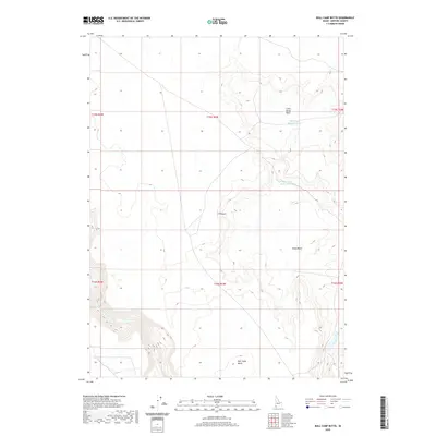
2020 Map of Bull Camp Butte
USGS Topo · Published 2020About this map
Bull Camp Butte rises as a prominent landmark in this corner of Owyhee County, overlooking a landscape defined by expansive high-desert basins and river drainage systems. The South Fork Owyhee River cuts through the southwestern section of the map, carving through the terrain as it passes the vast Y P Desert. This region is characterized by water management features essential for ranching and wildlife in an arid environment, including the Little Horse Basin Reservoir and West Horse Basin Reservoir. These reservoirs are situated within the natural depressions of Little Horse Basin and Horse Basin, which provide a clear view of the geographic relief and drainage patterns of the Idaho desert. The map captures the infrastructure of land management with township and range lines marking the intersection of six different blocks, illustrating the administrative organization of this expansive public land.
Find a feature on this map
13 named features on this map. Tap any name to fly to it.
Don’t see what you’re looking for? This feature index may not catch every label — zoom into the map to look around manually.
Map Details
Editions of this 2020 Bull Camp Butte Map
This is the sole edition of this map. No revisions or reprints were ever made.
Other maps of this area

1955 · McDermitt
USGS Topo · 1:250,000

1955 · Jordan Valley
USGS Topo · 1:250,000

1957 · Jordan Valley
USGS Topo · 1:250,000

1958 · Jordan Valley
USGS Topo · 1:250,000

1959 · McDermitt
USGS Topo · 1:250,000

1973 · Coyote Hole
USGS Topo · 1:24,000
1973 · Piute Basin West
USGS Topo · 1:24,000

1973 · Grassy Ridge
USGS Topo · 1:24,000

1973 · Bull Camp Butte
USGS Topo · 1:24,000
1973 · Star Valley Ridge East
USGS Topo · 1:24,000