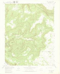
1960 Map of Bull Canyon
USGS Topo · Published 1980About this map
Indian Henrys Cabin and several remote mining outposts define this rugged corner of Southwest Colorado. The landscape is dominated by heavy industrial activity, particularly on Monogram Mesa and Wild Steer Mesa, where a dense network of claims like the Pluto Mine, Aztec Mine, and Wild Steer Mines are connected by the Monogram Trucks Route. In the south, the terrain falls away toward the Dolores River and is carved by deep drainages like Bull Canyon and Wild Horse Draw. The presence of established sites such as Wedding Bell Camp and Bachelor Camp suggests a landscape shaped by persistent prospecting and mineral extraction. This 1960 revision provides a detailed view of the infrastructure supporting the uranium and vanadium mining era, including numerous named pits and airstrips carved into the mesas.
Find a feature on this map
59 named features on this map. Tap any name to fly to it.
Don’t see what you’re looking for? This feature index may not catch every label — zoom into the map to look around manually.
Map Details
Editions of this 1960 Bull Canyon Map
4 editions found
Other maps of this area

1916 · Paradox Valley
USGS Topo · 1:125,000

1922 · Paradox Valley
USGS Topo · 1:125,000

1948 · Bull Canyon
USGS Topo · 1:24,000

1948 · Horse Range Mesa
USGS Topo · 1:24,000

1948 · Uravan
USGS Topo · 1:24,000

1948 · Hamm Canyon
USGS Topo · 1:24,000

1948 · Naturita NW
USGS Topo · 1:24,000

1948 · Paradox
USGS Topo · 1:24,000

1948 · Gypsum Gap
USGS Topo · 1:24,000

1949 · Bull Canyon
USGS Topo · 1:24,000