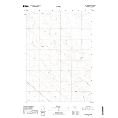
2017 Map of Bull Creek Butte
USGS Topo · Published 2017About this map
Bull Creek Butte dominates the central landscape of this Butte County terrain, where an intricate network of seasonal drainages carves through the South Dakota plains. The map reveals a remote ranching landscape defined by its hydrography, including the winding paths of S Fork Owl Cr and Owl Cr. The convergence of numerous named creeks such as Pearl Cr, Slate Cr, and Magpie Cr suggests a complex watershed that has long shaped land use and property boundaries in this part of the state. Local transit is limited to a few established routes like Kiplinger Rd and Gates-Waite Rd, which provide the primary access to these rangelands. Further south, the terrain is marked by Boxelder Cr, Crow Cr, and Roundout Cr, illustrating the rugged erosional patterns characteristic of the region's geography.
Find a feature on this map
20 named features on this map. Tap any name to fly to it.
Don’t see what you’re looking for? This feature index may not catch every label — zoom into the map to look around manually.
Map Details
Editions of this 2017 Bull Creek Butte Map
This is the sole edition of this map. No revisions or reprints were ever made.
Other maps of this area

1901 · Aladdin
USGS Topo · 1:125,000

1903 · Aladdin
USGS Topo · 1:125,000

1905 · Indian
USGS Topo · 1:62,500

1907 · Belle Fourche
USGS Topo · 1:125,000

1907 · Redwater
USGS Topo · 1:62,500

1953 · Rapid City
USGS Topo · 1:250,000

1954 · The Forks
USGS Topo · 1:24,000
1954 · Belle Fourche
USGS Topo · 1:24,000

1954 · Gillette
USGS Topo · 1:250,000

1955 · Gillette
USGS Topo · 1:250,000