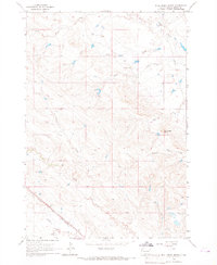
1965 Map of Bull Creek Butte
USGS Topo · Published 1967About this map
Bull Creek Butte rises as a prominent landmark in this mid-1960s survey of the High Plains, where the drainage networks of South Fork Owl Creek and Middle Creek define the landscape. The map captures a ranching economy organized around water and rail, with several established family holdings including Coe Ranch and Kiplinger Ranch situated near the seasonal creek beds. In the southwestern corner, the Chicago and North Western rail line cuts diagonally across the terrain, reflecting the vital transport link for this corner of Butte County. The intricate contour lines illustrate a series of breaks and draws such as Roundout, providing a detailed view of the land before modern agricultural and infrastructure shifts altered the local footprint. This survey is particularly useful for identifying historical fence lines and field boundaries as they existed during the mid-century.
Find a feature on this map
16 named features on this map. Tap any name to fly to it.
Don’t see what you’re looking for? This feature index may not catch every label — zoom into the map to look around manually.
Map Details
Editions of this 1965 Bull Creek Butte Map
This is the sole edition of this map. No revisions or reprints were ever made.
Other maps of this area

1901 · Aladdin
USGS Topo · 1:125,000

1903 · Aladdin
USGS Topo · 1:125,000

1905 · Indian
USGS Topo · 1:62,500

1907 · Belle Fourche
USGS Topo · 1:125,000

1907 · Redwater
USGS Topo · 1:62,500

1953 · Rapid City
USGS Topo · 1:250,000

1954 · The Forks
USGS Topo · 1:24,000
1954 · Belle Fourche
USGS Topo · 1:24,000

1954 · Gillette
USGS Topo · 1:250,000

1955 · Gillette
USGS Topo · 1:250,000