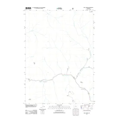
2012 Map of Bull Creek
USGS Topo · Published 2012About this map
The Hoback River carves a central path through this portion of the Gros Ventre Range, dictating the movement and recreational patterns of Teton County. At this stage in the early 21st century, the landscape is defined by its drainage systems and prominent summits, including Cream Puff Peak and Battle Mountain. The presence of established sites like Hoback Campground and Kozy Campground along the riverbanks illustrates the area's long-standing role as a gateway for travelers and outdoorsmen.
Find a feature on this map
21 named features on this map. Tap any name to fly to it.
Don’t see what you’re looking for? This feature index may not catch every label — zoom into the map to look around manually.
Map Details
Editions of this 2012 Bull Creek Map
This is the sole edition of this map. No revisions or reprints were ever made.
Other maps of this area

1907 · Gros Ventre
USGS Topo · 1:125,000

1910 · Gros Ventre
USGS Topo · 1:125,000

1931 · Jackson
USGS Topo · 1:125,000

1935 · Jackson
USGS Topo · 1:125,000

1955 · Driggs
USGS Topo · 1:250,000

1958 · Driggs
USGS Topo · 1:250,000

1962 · Driggs
USGS Topo · 1:250,000

1965 · Camp Davis
USGS Topo · 1:24,000
1965 · Turquoise Lake
USGS Topo · 1:24,000
1965 · Cache Creek
USGS Topo · 1:24,000