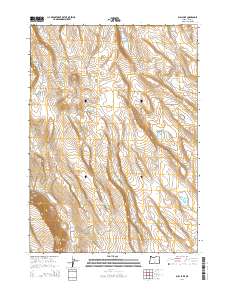
2014 Map of Bull Lake
USGS Topo · Published 2014About this map
The high desert landscape of Lake County is defined here by intermittent water sources and dramatic volcanic topography. Surface water is sparse, represented by seasonal features like Bull Lake and Whiskey Lake, while cattle ranching and wildlife management are supported by several named waterholes including Long Dogs Waterhole and the descriptively named Broken Coffee Pot Waterhole. The terrain transitions from the high elevations of the Whiskey Mtn and the Whiskey Hills down toward the prominent Diablo Rim in the southwest. This area, largely devoid of permanent settlements, is accessed primarily by unpaved tracks such as Sheep Rock Rd. The map illustrates a section of the Oregon outback where survival depends on the seasonal accumulation of water in natural basins and improved catchments across the high plateau.
Find a feature on this map
16 named features on this map. Tap any name to fly to it.
Don’t see what you’re looking for? This feature index may not catch every label — zoom into the map to look around manually.
Map Details
Editions of this 2014 Bull Lake Map
This is the sole edition of this map. No revisions or reprints were ever made.
Other maps of this area

1955 · Crescent
USGS Topo · 1:250,000

1955 · Klamath Falls
USGS Topo · 1:250,000

1957 · Crescent
USGS Topo · 1:250,000

1958 · Crescent
USGS Topo · 1:250,000

1958 · Klamath Falls
USGS Topo · 1:250,000

1970 · Crescent
USGS Topo · 1:250,000

1974 · Lake Abert
USGS Topo · 1:100,000

1985 · Sharp Top
USGS Topo · 1:24,000
1985 · Fire Lake
USGS Topo · 1:24,000
1985 · Biscuit Point
USGS Topo · 1:24,000