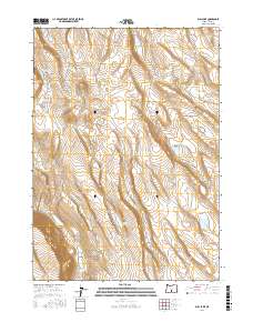
2017 Map of Bull Lake
USGS Topo · Published 2017About this map
Whiskey Hills and the prominent Diablo Rim define this high-desert basin in southern Oregon. The landscape is characterized by its internal drainage, where seasonal water sources like Whiskey Lake, East Whiskey Lake, and Bull Lake collect in the depressions between arid ridges. The presence of the uniquely named Broken Coffee Pot Waterhole points to the area's history of livestock grazing and the critical importance of reliable water points in the Lake County rangelands. This 2017 survey reflects a remote terrain structured by the Public Land Survey System, specifically within t30s r19e and t31s r19e, where the interplay of elevation and intermittent hydrology continues to dictate the use of the land.
Find a feature on this map
10 named features on this map. Tap any name to fly to it.
Don’t see what you’re looking for? This feature index may not catch every label — zoom into the map to look around manually.
Map Details
Editions of this 2017 Bull Lake Map
This is the sole edition of this map. No revisions or reprints were ever made.
Other maps of this area

1955 · Crescent
USGS Topo · 1:250,000

1955 · Klamath Falls
USGS Topo · 1:250,000

1957 · Crescent
USGS Topo · 1:250,000

1958 · Crescent
USGS Topo · 1:250,000

1958 · Klamath Falls
USGS Topo · 1:250,000

1970 · Crescent
USGS Topo · 1:250,000

1974 · Lake Abert
USGS Topo · 1:100,000

1985 · Sharp Top
USGS Topo · 1:24,000
1985 · Fire Lake
USGS Topo · 1:24,000
1985 · Biscuit Point
USGS Topo · 1:24,000