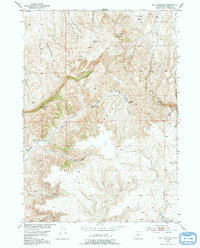
1952 Map of Bull Mountain
USGS Topo · Published 1991About this map
Isolated sheep and cattle ranching operations define this high-desert landscape in the mid-twentieth century. The territory is anchored by family-named landmarks such as the Justin McCarthy Ranch and David McCarthy Ranch, illustrating the dispersed settlement pattern typical of this corner of the Missouri River Basin. These homesteads rely on a series of drainages, including Bridger Creek and Lysite Creek, which cut through the high terrain between Bull Mountain and Klondike Peak. The presence of the historic Bridger Road winding through the center of the map highlights a legacy of movement and commerce through the Basin. Researchers will find a meticulously documented network of unimproved roads and seasonal water sources like Nowater Creek, providing a detailed record of the land use before more modern infrastructure altered the rural character of the region.
Find a feature on this map
21 named features on this map. Tap any name to fly to it.
Don’t see what you’re looking for? This feature index may not catch every label — zoom into the map to look around manually.
Map Details
Editions of this 1952 Bull Mountain Map
3 editions found
Other maps of this area

1952 · Cottonwood Pass
USGS Topo · 1:24,000

1952 · Rathbun Ranch
USGS Topo · 1:24,000

1952 · Arapahoe Butte
USGS Topo · 1:24,000

1952 · De Pass
USGS Topo · 1:24,000

1952 · Battle Mountain
USGS Topo · 1:24,000

1952 · Bull Mountain
USGS Topo · 1:24,000

1955 · Arminto
USGS Topo · 1:250,000

1957 · Rathbun Ranch
USGS Topo · 1:24,000

1958 · Arminto
USGS Topo · 1:250,000

1960 · Packsaddle Creek
USGS Topo · 1:24,000