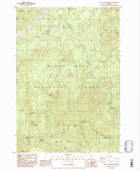
1985 Map of Bull of The Woods
USGS Topo · Published 1986About this map
Mount Hood National Forest terrain dominates this mid-1980s survey, centered on the high peaks and drainages of the Collawash River watershed. The landscape is defined by its significant elevation changes, ranging from the heights of Bull of the Woods Lookout and Schreiner Peak down to the creek-fed basins. While the area is largely dedicated to conservation and recreation, evidence of small-scale resource extraction appears at the Quarry and various Borrow Pit sites.
Find a feature on this map
46 named features on this map. Tap any name to fly to it.
Don’t see what you’re looking for? This feature index may not catch every label — zoom into the map to look around manually.
Map Details
Editions of this 1985 Bull of The Woods Map
This is the sole edition of this map. No revisions or reprints were ever made.
Other maps of this area

1916 · Estacada
USGS Topo · 1:125,000

1924 · Mount Hood
USGS Topo · 1:125,000

1927 · Mount Hood
USGS Topo · 1:125,000

1927 · Mt. Jefferson
USGS Topo · 1:125,000

1929 · Mill City
USGS Topo · 1:125,000

1930 · Mt. Jefferson
USGS Topo · 1:125,000

1948 · Vancouver
USGS Topo · 1:250,000

1950 · Vancouver
USGS Topo · 1:250,000

1950 · Vancouver
USGS Topo · 1:250,000

1953 · Salem
USGS Topo · 1:250,000