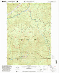
1997 Map of Bull of the Woods
USGS Topo · Published 1999About this map
Bull of the Woods Wilderness dominates this late-twentieth-century landscape where Clackamas and Marion counties meet. The high-altitude terrain is anchored by the Bull of the Woods Lookout and the massive drainage system of the Collawash River, which is fed by numerous tributaries including the Kingfisher Fork and Elk Lake Creek. This period of forest management is reflected in the network of resource extraction sites such as the Lily Pad Quarry and Russ Creek Quarry, while the preservation of the back-country is evident in the cluster of alpine water bodies like Welcome Lakes, Big Slide Lake, and Lake Lenore. The presence of Toms Meadow and the Alder Swamp highlights the varied ecology within the Mt Hood National Forest before more modern developments. This survey documents the intersection of industrial forest roads and protected wilderness peaks at a time of transitioning land use priorities.
Find a feature on this map
54 named features on this map. Tap any name to fly to it.
Don’t see what you’re looking for? This feature index may not catch every label — zoom into the map to look around manually.
Map Details
Editions of this 1997 Bull of the Woods Map
This is the sole edition of this map. No revisions or reprints were ever made.
Other maps of this area

1916 · Estacada
USGS Topo · 1:125,000

1924 · Mount Hood
USGS Topo · 1:125,000

1927 · Mount Hood
USGS Topo · 1:125,000

1927 · Mt. Jefferson
USGS Topo · 1:125,000

1929 · Mill City
USGS Topo · 1:125,000

1930 · Mt. Jefferson
USGS Topo · 1:125,000

1948 · Vancouver
USGS Topo · 1:250,000

1950 · Vancouver
USGS Topo · 1:250,000

1950 · Vancouver
USGS Topo · 1:250,000

1953 · Salem
USGS Topo · 1:250,000