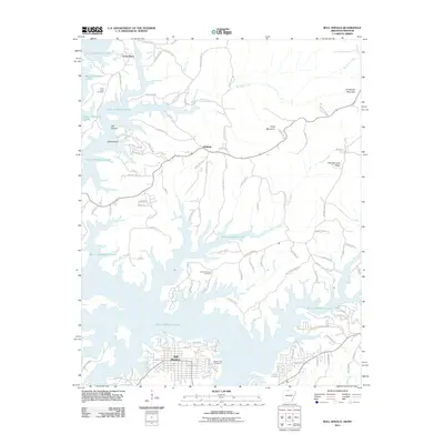
2011 Map of Bull Shoals
USGS Topo · Published 2011About this map
Bull Shoals Lake dominates the center of this 2011 survey, its dendritic shoreline reaching deep into the Ozark plateaus along the Arkansas-Missouri border. The settlement of Bull Shoals occupies the southern peninsula, where a dense grid of streets meets the water's edge at Ferncliff Pt. The map reveals a landscape defined by ridges and hollows, such as Promise Land Ridge and Oak Hollow, where small communities and family-named landmarks persist near the reservoir's edge. Genealogists can locate several historic burial grounds including Price Place Cemetery near the Missouri line, Promised Land Cemetery, and Newton Flat Cemetery in the southern portion of the quadrangle. Smaller settlements like Oakland and Price Place are connected by a network of county roads that navigate the complex topography created by the winding lake and its tributaries like Sister Creek.
Find a feature on this map
96 named features on this map. Tap any name to fly to it.
Don’t see what you’re looking for? This feature index may not catch every label — zoom into the map to look around manually.
Map Details
Editions of this 2011 Bull Shoals Map
This is the sole edition of this map. No revisions or reprints were ever made.
Other maps of this area

1890 · Mountain Home
USGS Topo · 1:125,000

1891 · Mountain Home
USGS Topo · 1:125,000

1893 · Yellville
USGS Topo · 1:125,000

1894 · Mountain Home
USGS Topo · 1:125,000

1903 · Yellville
USGS Topo · 1:125,000

1905 · Yellville
USGS Topo · 1:125,000

1929 · Yellville
USGS Topo · 1:125,000

1934 · Gainesville
USGS Topo · 1:48,000

1936 · Thornfield
USGS Topo · 1:48,000

1940 · Gainesville
USGS Topo · 1:62,500