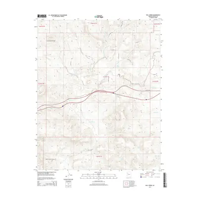
2014 Map of Bull Spring
USGS Topo · Published 2014About this map
The Cottonwood Mountains and the Aquarius Mountains dominate this high-desert landscape in Mohave County, where water sources dictated the movement of livestock and travelers. This 2014 survey documents a network of critical watering points, including the eponymous Bull Spring and several others such as Casa Grande Spring, Cottonwood Spring, and Knight Creek Spring. The presence of numerous tanks like White Rock Tank, Rucker Tank, and Three Sisters Tank illustrates the modern ranching infrastructure necessary for survival in this arid environment. Transportation across the drainage systems of Willow Cr and Tuckayou Wash is facilitated by a grid of named rural tracks and trails, including Knight Creek Rd and E Fort Rock Rd. These routes connect the rugged canyons and washes, providing a detailed map of access in a region defined by its topographic extremes and vital hydraulic features.
Find a feature on this map
32 named features on this map. Tap any name to fly to it.
Don’t see what you’re looking for? This feature index may not catch every label — zoom into the map to look around manually.
Map Details
Editions of this 2014 Bull Spring Map
This is the sole edition of this map. No revisions or reprints were ever made.
Other maps of this area

1886 · Diamond Creek
USGS Topo · 1:250,000

1892 · Diamond Creek
USGS Topo · 1:250,000

1948 · Williams
USGS Topo · 1:250,000

1954 · Williams
USGS Topo · 1:250,000

1956 · Williams
USGS Topo · 1:250,000

1960 · Williams
USGS Topo · 1:250,000

1961 · Williams
USGS Topo · 1:250,000
1968 · Austin Peak
USGS Topo · 1:24,000
1968 · Tin Mountain
USGS Topo · 1:24,000
1968 · Valentine SE
USGS Topo · 1:24,000