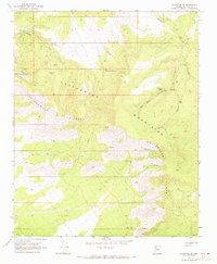
1968 Map of Valentine SE
USGS Topo · Published 1971About this map
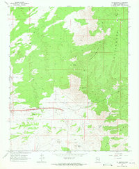
Mining operations and remote desert springs define this late 1960s landscape in the high desert of Arizona. A concentration of mineral claims appears in the northwest, including the Copper Giant Mine, Alabama Mine, and the Walkover Mine, where topographic lines reveal the steep approaches to these mountain workings. This period of the survey shows the critical importance of water management in an arid climate, with numerous corrals, water tanks, and a long north-south Aqueduct cutting through the terrain. The dramatic transition between the Cottonwood Cliffs and the Cottonwood Mountains is marked by deep drainages like Wright Canyon and Red Horn Canyon, which provide natural routes through the elevation changes. Evidence of local ranching and prospecting is found at isolated points like Little Cottonwood Spring and Red Horn Spring, connected by an sparse network of Jeep trails.
Find a feature on this map
21 named features on this map. Tap any name to fly to it.
Don’t see what you’re looking for? This feature index may not catch every label — zoom into the map to look around manually.
Map Details
Editions of this 1968 Valentine SE Map
2 editions found
Other maps of this area

1886 · Diamond Creek
USGS Topo · 1:250,000

1892 · Diamond Creek
USGS Topo · 1:250,000

1948 · Williams
USGS Topo · 1:250,000

1954 · Williams
USGS Topo · 1:250,000

1956 · Williams
USGS Topo · 1:250,000

1960 · Williams
USGS Topo · 1:250,000

1961 · Williams
USGS Topo · 1:250,000
1968 · Truxton
USGS Topo · 1:24,000
1968 · Hackberry
USGS Topo · 1:24,000
1968 · Tin Mountain
USGS Topo · 1:24,000