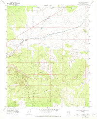
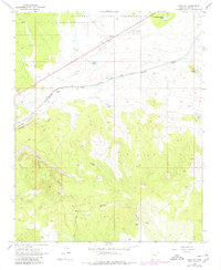
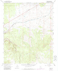
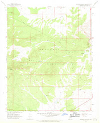
1968 Map of Truxton
USGS Topo · Published 1971About this map
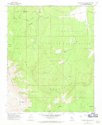
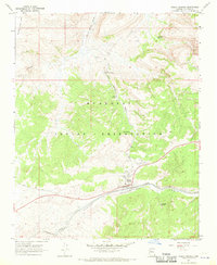
Truxton sits at the northern edge of this Mojave County landscape, where the Atchison Topeka and Santa Fe railroad tracks cut a definitive path across the high desert floor. The map documents a critical transportation corridor following Truxton Wash, supported by infrastructure like the Truxton (Siding) and a local Borrow Pit. To the north, the boundary of the Hualapai Indian Reservation defines the land use, while to the south, the terrain breaks into the dramatic vertical relief of the Cottonwood Cliffs. The interior is marked by a network of drainage systems and isolated water sources essential for cattle ranching or transit, including Shipping Pasture Tank, Dead Cow Tank, and Walkover Tank. Steep descents through Truxton Canyon and Wright Canyon reveal the complex geography that challenged early surveyors and railroad engineers alike.
Find a feature on this map
19 named features on this map. Tap any name to fly to it.
Don’t see what you’re looking for? This feature index may not catch every label — zoom into the map to look around manually.
Map Details
Editions of this 1968 Truxton Map
3 editions found
Other maps of this area

1886 · Diamond Creek
USGS Topo · 1:250,000

1892 · Diamond Creek
USGS Topo · 1:250,000

1948 · Williams
USGS Topo · 1:250,000

1954 · Williams
USGS Topo · 1:250,000

1956 · Williams
USGS Topo · 1:250,000

1960 · Williams
USGS Topo · 1:250,000

1961 · Williams
USGS Topo · 1:250,000
1967 · Milkweed Canyon SE
USGS Topo · 1:24,000
1967 · Milkweed Canyon SW
USGS Topo · 1:24,000
1967 · Peach Springs
USGS Topo · 1:24,000