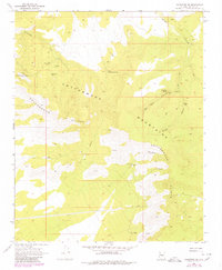
1968 Map of Valentine SE
USGS Topo · Published 1980About this map
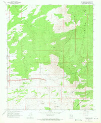
Mining operations such as the Copper Giant Mine and Alabama Mine characterize this mid-century look at the high desert terrain of the Mountains in Mohave County. Mapping based on 1967 and 1968 fieldwork shows a landscape defined by sharp elevation changes along the Cottonwood Cliffs, where water sources like Little Cottonwood Spring and Red Horn Spring provided essential relief in the arid environment. A network of primitive infrastructure, including an Aqueduct, Pipeline, and numerous corrals, suggests a dual economy of resource extraction and livestock grazing. Navigating the depths of Wright Canyon and Red Horn Canyon, prospectors and ranchers utilized a series of Jeep Trails to reach remote claims like the Keystone Extension Mine and Victoria Mine long before modern development altered the region.
Find a feature on this map
19 named features on this map. Tap any name to fly to it.
Don’t see what you’re looking for? This feature index may not catch every label — zoom into the map to look around manually.
Map Details
Editions of this 1968 Valentine SE Map
2 editions found
Other maps of this area

1886 · Diamond Creek
USGS Topo · 1:250,000

1892 · Diamond Creek
USGS Topo · 1:250,000

1948 · Williams
USGS Topo · 1:250,000

1954 · Williams
USGS Topo · 1:250,000

1956 · Williams
USGS Topo · 1:250,000

1960 · Williams
USGS Topo · 1:250,000

1961 · Williams
USGS Topo · 1:250,000
1968 · Truxton
USGS Topo · 1:24,000
1968 · Hackberry
USGS Topo · 1:24,000
1968 · Tin Mountain
USGS Topo · 1:24,000