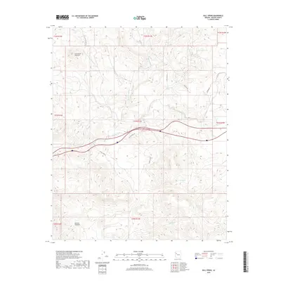
2018 Map of Bull Spring
USGS Topo · Published 2018About this map
The Cottonwood Mountains and Aquarius Mountains define this high-desert landscape in Mohave County, where life and travel are dictated by the presence of vital water sources. Numerous watering points are documented across this arid terrain, including Bull Spring, Casa Grande Spring, Mud Spring, and Cottonwood Spring. The drainage patterns are clearly marked by the winding paths of Willow Creek, Tuckayou Wash, and Lookout Wash, which underscore the geological character of the region. A sparse network of local roads and trails, such as Willow Ranch Rd, Flying Eagle Rd, and W Mohave Kid Rd, provides access through the various township and range sections. This 2018 survey reveals a landscape largely shaped by ranching infrastructure and natural landmarks, including the curiously named B Flat Tank.
Find a feature on this map
27 named features on this map. Tap any name to fly to it.
Don’t see what you’re looking for? This feature index may not catch every label — zoom into the map to look around manually.
Map Details
Editions of this 2018 Bull Spring Map
This is the sole edition of this map. No revisions or reprints were ever made.
Other maps of this area

1886 · Diamond Creek
USGS Topo · 1:250,000

1892 · Diamond Creek
USGS Topo · 1:250,000

1948 · Williams
USGS Topo · 1:250,000

1954 · Williams
USGS Topo · 1:250,000

1956 · Williams
USGS Topo · 1:250,000

1960 · Williams
USGS Topo · 1:250,000

1961 · Williams
USGS Topo · 1:250,000
1968 · Austin Peak
USGS Topo · 1:24,000
1968 · Tin Mountain
USGS Topo · 1:24,000
1968 · Valentine SE
USGS Topo · 1:24,000